 (Reprinted from United Nations Environment Programme: http://www.unep-wcmc.org/sites/wh/kilimanj.html)
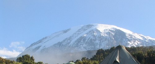
At 5,895 m, Kilimanjaro is the highest point in Africa. This volcanic massif stands in splendid isolation above the surrounding plains, with its snowy peak looming over the savannah. The mountain is encircled by mountain forest. Numerous mammals, many of them endangered species, live in the park.
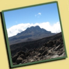
Kilimanjaro is a giant stratovolcano and one of the largest volcanoes in the world. It is the highest mountain in Africa, rising 4,877m above the surrounding savanna plains to 5,895m and covers an area of about 388,500ha. It stands alone but is the largest of an east-west belt of volcanoes across northern Tanzania. It has three main volcanic peaks of varying ages lying on an east-southeast axis, and a number of smaller parasitic cones. To the west, the oldest peak Shira (3,962m) of which only the western and southern rims remain, is a relatively flat upland plateau of some 6,200ha, the northern and eastern flanks having been covered by later material from Kibo. The rugged erosion-shattered peak of Mawenzi (5,149m) lies to the east. The top of its western face is fairly steep with many crags, pinnacles and dyke swarms. Its eastern side falls in cliffs over 1000m high in a complex of gullies and rock faces, rising above two deep gorges, the Great Barranco and the Lesser Barranco. Kibo (5,895m), is the most recent summit, having last been active in the Pleistocene and still has minor fumaroles. It consists of two concentric craters of 1.9 x 2.7km and 1.3km in diameter with a 350m deep ash pit in the centre. The highest point on the mountain is the southern rim of the outer crater. Between Kibo and Mawenzi there is a plateau of some 3600ha, called the Saddle, which forms the largest area of high altitude tundra in tropical Africa. There are deep radial valleys especially on the western and southern slopes.
 CLIMATE
There are two wet seasons, November to December and March to May, with the driest months between August to October. Rainfall decreases rapidly with increase in altitude; mean precipitation is 2300mm in the forest belt (at1,830m), 1300mm at Mandara hut on the upper edge of the forest (2,740m), 525mm at Horombo hut in the moorland (3,718m), and less than 200mm at Kibo hut (4,630m), giving desert-like conditions. The prevailing winds, influenced by the trade winds, are from the southeast. North-facing slopes receive far less rainfall. January to March are the warmest months. Conditions above 4000m can be extreme and the diurnal temperature range there is considerable. Mist frequently envelopes much of the massif but the former dense cloud cover is now rare.
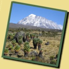
VEGETATION
The mountain has five main vegetation zones: savanna bushland at 700-1,000m (south slopes) and 1,400-1,600m (north slopes), densely populated sub-montane agro-forest on southern and southeastern slopes, the montane forest belt, sub-alpine moorland and alpine bogs. Above this is alpine desert. The montane forest belt circles the mountain between 1,300m (~1,600m on the drier north slopes) to 2,800m. Forests above 2,700m are within the National Park (Greenway, 1965). According to Lambrechts et al. (2001) there are 2,500 plant species on the mountain, 1,600 of them on the southern slopes and 900 within the forest belt. There are 130 species of trees with the greatest diversity being between 1,800 and 2,000 meters. There are also 170 species of shrubs, 140 species of epiphytes, 100 lianas and 140 pteridophytes.
The forest between 1,000 and 1,700m in the south and east has been extensively farmed with remnants of natural forest left only in deep gorges. Dominant species of the submontane forest between 1,300-1,600m in the west and 1,600-2,000m in the north are Croton megalocarpus and Calodendron capense; and of the lower to middle montane forest between 1,600-2,200m in the west and 2,000-2,400m in the north is Cassipourea malosana.On the southern and southeastern slopes from 1,600 to 2,100m the dominant lower montane forest species is camphorwood Ocotea usambarensis; from 2,100 to 2,400m the dominant middle montane forest species are camphorwood Ocotea usambarensis with yellowwood Podocarpus latifolius, a large evergreen, with the tree fern Cyathea manniana, sometimes growing to 7m high. From 2,400 to 2,800m the dominant upper montane forest species are Podocarpus latifolius with Ocotea usambarensis. The subalpine southern and southeastern slopes between 2,800-3,100m have forest of Hagenia abyssinica with Podocarpus latifolius and Prunus Africana; and on the north slopes Juniperus procera - Podocarpus latifolius forest with Hagenia abyssinica. Above 2,800m to the edge of the tundra at 3,500m is Erica excelsa forest.
 There is no bamboo zone, nor a Hagenia-Hypericum zone. Above about 4,600m, very few plants are able to survive the severe conditions, although specimens of Helichrysum newii have been recorded as high as 5,760m (close to a fumarole), and mosses and lichens are found right up to the summit. The upland moor consists primarily of heath/scrub plants, with Erica excelsa, Philippia trimera, Adenocarpus mannii, Protea kilimandscharica, Stoebe kilimandscharica, Myrica meyeri-johannis, and Myrsine africana. Grasses are abundant in places, and Cyperaceae form the dominant ground cover in wet hollows. On flatter areas between the upland moor and the forest edge are areas of moorland or upland grassland composed of Agrostis producta, Festuca convoluta, Koeleria gracilis , Deschampsia sp., Exotheca abyssinica, Andropogon amethystinus, and A. kilimandscharicus, with scattered bushes of Adenocarpus mannii, Kotschya recurvifolia and Myrica meyeri-johannis. Various species of Helichrysum are found in the grasslands and in the upland moor. Two distinct forms of giant groundsel occur on the upper mountain: Senecio johnstonii cottonii, endemic to the mountain and only occurring above 3600m, and S.johnstonii johnstonii which occurs between 2,450m and 4,000m, and shows two distinct forms. At all altitudes Senecio favours the damper and more sheltered locations, and in the alpine bogs is associated with another conspicuous plant, growing up to 10m tall, the endemic giant lobelia Lobelia deckenii. Below the tree line, the park includes six corridors through the forest to the mountain foot.
FAUNA
The whole mountain including the montane forest belt, part of which extends into the National Park, is very rich in species: 140 mammals, (87 forest species), including 7 primates, 25 carnivores, 25 antelopes and 24 species of bat (Lamprecht et al.,2002).Above the treeline at least seven of the larger mammal species have been recorded (Child, 1965), although it is likely that many of these also use the lower montane forest habitat. The most frequently encountered mammals above the treeline are Kilimanjaro tree hyrax Dendrohyrax validus (VU), grey duiker Sylvicapra grimmia and eland Taurotragus oryx, which occur in the moorland, with bushbuck Tragelaphus scriptus and red duiker Cephalophus natalensis being found above the treeline in places, and buffalo Syncerus caffer occasionally moves out of the forest into the moorland and grassland. An estimated 220 elephants Loxodonta africana (EN) are distributed between the Namwai and the Tarakia Rivers (Tanzania National Parks, 1993) and sometimes occur on the higher slopes. Insectivores occur and rodents are plentiful above the tree line, especially at times of population explosion, although golden moles (Chrysochloridae) are absent. Three species of primate are found within the montane forests, blue monkey Cercopithecus mitis, western black and white colobus Colobus polykomos abyssinicus, and bushbaby Galago sp. and among mammals found there are leopards Panthera pardus, as well as some of the species listed above. Abbot's duiker Cephalophus spadix (VU) is restricted to Kilimanjaro and some neighbouring mountains. Black rhinoceros Diceros bicornis (CR) is now extinct in the area and mountain reedbuck Redunca fulvorufula is probably extinct (Lamprecht et al.,2002).
Although 179 highland bird species have been recorded for the mountain, species recorded in the upper zones are few in number, although they include occasional lammergeier Gypaetus barbatus, mainly on the Shira ridge, hill chat Cercomela sordida, Hunter's cisticola Cisticola hunteri, and scarlet-tufted malachite sunbird Nectarinia johnstoni. White-necked raven Corvus albicollis is the most conspicuous bird species at higher altitude. The forest has several notable bird species including Abbot's starling Cinnyricinclus femoralis, which has a very restricted distribution. The butterfly Papilio sjoestedti, sometimes known as the Kilimanjaro swallowtail, is restricted to Kilimanjaro, Ngorongoro and Mount Meru, although the subspecies P.atavus is found only on Kilimanjaro.
LOCAL HUMAN POPULATION
The area surrounding the mountain is quite heavily populated principally by the Chagga people and the northern and western slopes of the Forest Reserve surrounding the National Park has 18 medium to large 'forest villages'. Although it is illegal these people still use the forest for many household and medicinal products, for fuelwood, small scale farming, beekeeping, hunting, charcoal production and logging. Some 12% of the forest is plantation, some almost reaching to the moorland. The shamba system of tree plantations interplanted with crops comprises over half the planted area but over half of it is not replanted with trees at all (Lamprecht et al.,2002).
VISITORS AND VISITOR FACILITIES
The National Park has been developed with tourism in mind, and approximately 10,800 people visit the park each year. The mountain can be climbed by non-climbers and the tour is increasing in popularity. All visitors climbing the mountain must have a guide preferably from a licensed tour operator and take precautions against mountain sickness. Although there are six routes up the mountain, 91% of all hikers use the Marangu Trail. There are three huts for climbers on this trail: Mandara, Horombo and Kibo. Food, bedding and porters are provided by tour operators. There is a mountain rescue team at the park headquarters and at each of the huts At Marangu there are a lodge, a hostel, a shop and equipment rental (National Park Service, pers.comm.,1995).
SCIENTIFIC RESEARCH AND FACILITIES
A variety of scientific studies have been conducted within the park, although there are no special facilities. There has been long-term geological, hydrological and vulcanological research by the Geology Department of the University of Tanzania and Sheffield University in the United Kingdom which is of particular interest. There is potential for further work, particularly in relation to glaciology and world climate. The College of African Wildlife Management at Mweka, and its facilities, is relatively close.
CONSERVATION VALUE
With its snow-capped peak standing alone almost 5km above the surrounding plains Mt. Kilimanjaro is a superlative natural feature and a powerful symbol of the country. It is also an essential water catchment for the surrounding countryside and protects wildlife and a unique endemic flora
CONSERVATION MANAGEMENT
Although protection is total within the park, and access is restricted, management is still not entirely adequate. A management plan, prepared in 1993, outlines the following objectives: to protect and maintain the park's natural resources; to increase interpretation and visitor information; to encourage visitor use and development in a sustainable fashion; to improve park operations; and to strengthen the park's relationship with local communities. A number of boundary adjustments and land protection strategies were described. These include gazetting forest reserve lands to the National Park with the exception of the pine and cypress plantations and the half-mile strip below the forest, which would be returned to village government control under sustained yield practices to provide local resource benefits; initiating an 'Integrated Regional Conservation Plan' to lessen the local community's dependence on the mountain's forest resources; gazetting the portion of Lake Chala within Tanzania into the National Park; and reaffirming and encouraging full implementation of Mounduli District Council bylaws to provide complete protection for the North Kilimanjaro Migration Corridor. A zoning scheme, defining limits of acceptable use, has been implemented for the National Park and Forest Reserve areas. Seven zones have been identified: intensive use hiking zone (2,700ha), low use hiking zone (summit- bound) (7,723ha), low use hiking zone (non-summit bound) (3,750ha), day use zone (598ha), wilderness zone (150,657ha), mountaineering zone (2,510ha), cultural protection zone (259ha), and administration zone (62ha) (Tanzania National Parks, 1993).